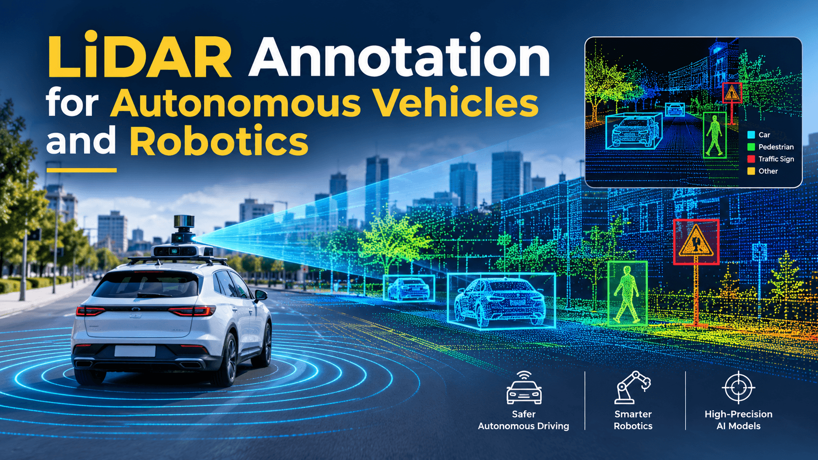

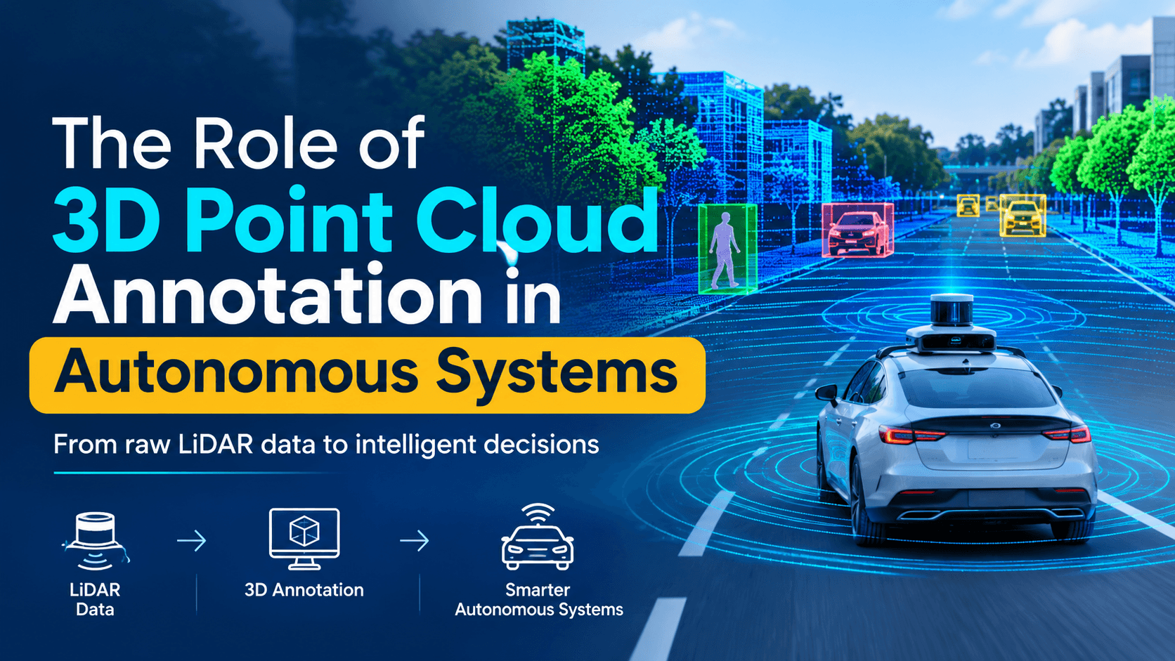
An autonomous system has one job that comes before everything else: know exactly what is around it and where. A robotaxi has to tell a parked car from one pulling out. A warehouse robot has to find a pallet's edge to within a few centimetres. A delivery drone has to spot a power line before it flies into it. Cameras alone struggle with this, because a flat image doesn't carry reliable distance. That is why most serious autonomy stacks also rely on LiDAR and depth sensors, which capture the world as a 3D point cloud.
But a raw point cloud is just millions of coordinates. It means nothing to a machine learning model until someone marks which points belong to a car, a pedestrian, a curb or a tree. That labelling work is 3D point cloud annotation, and it is one of the most important (and most expensive) steps in building any autonomous system.
This guide explains what point cloud annotation is, the main techniques, how it is used across autonomous vehicles, robotics and drones, the challenges teams run into, and the practices that keep quality high at scale.
What Is a 3D Point Cloud?
A point cloud is a set of points in three-dimensional space. Each point has X, Y and Z coordinates and often extra values such as reflectance (intensity), return number and a timestamp. Point clouds come from:
• LiDAR, which fires laser pulses and measures how long each one takes to bounce back. LiDAR gives precise distances and isn't affected by lighting the way cameras are.
• Stereo and RGB-D cameras, which estimate depth from two viewpoints or projected light; common in indoor robots.
• Radar, which produces much sparser points but works well in rain and fog.
• Photogrammetry and terrestrial scanners, used for mapping and digital twins.
The volumes are large. A single scan in the SemanticKITTI dataset holds roughly 120,000 points (Emergent Mind), and a fleet vehicle captures 10 or more scans every second. If you are new to the wider topic, start with our guide to sensor data collection for robotics.
What Is 3D Point Cloud Annotation?
3D point cloud annotation is the process of adding labels to points or groups of points so a model can learn from them. The labels describe what an object is (class), which individual object it is (instance ID), where it sits in space (position and size), which way it faces (heading), and how it moves over time (track ID and velocity).
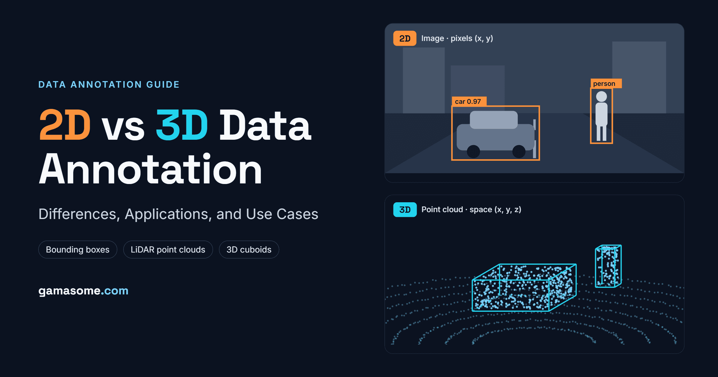
The difference from image annotation is that the annotator works in a 3D viewer, rotating the scene, checking top-down and side views, and fitting labels in three axes instead of two. For a full side-by-side comparison, see our post on 2D vs 3D data annotation.
Key Techniques in Point Cloud Annotation
3D Bounding Boxes (cuboids)
The workhorse of autonomy datasets. An annotator places an oriented box around each object, defined by its centre (x, y, z), its length, width and height in metres, and its yaw angle. Cuboids are fast compared with segmentation and give detection models everything they need to locate vehicles, pedestrians and cyclists.
Semantic Segmentation
Every point gets a class: road, sidewalk, building, vegetation, pole, vehicle and so on. This gives dense scene understanding, which is useful for drivable-area detection, mapping and off-road navigation, but it takes far more effort than cuboids.
Instance and Panoptic Segmentation
Instance segmentation separates individual objects (car #1, car #2). Panoptic segmentation combines both: countable objects get instance IDs, while background classes such as road and terrain get semantic labels.
Object Tracking (4D annotation)
The same object keeps one ID across consecutive frames, so models can learn motion, speed and trajectories. Prediction and planning modules depend on this.
Polylines and Polygons in 3D
Used for lane boundaries, curbs, road edges, stop lines and other map elements, often to build HD maps.
Attributes
Extra tags on each label: occlusion level, whether a vehicle is parked or moving, whether a pedestrian is standing or sitting, whether a door is open.
Sensor Fusion Annotation
Labels drawn in the point cloud are projected into synchronised camera images (and sometimes radar), so the same object has consistent IDs and attributes in every sensor. Read more in Sensor Fusion in Physical AI.
Why Point Cloud Annotation Matters for Autonomous Systems
It gives models real geometry
A camera-trained model learns that a pedestrian looks like a pedestrian. A point-cloud-trained model also learns that the pedestrian is 1.7 metres tall, 6 metres ahead and walking left. Braking, path planning and grasping all depend on these physical numbers.
It is the ground truth for safety
Annotated point clouds are used not only to train models but also to test them. Every claim that a perception system detects pedestrians at 50 metres in the rain needs labelled data to prove it. Weak labels mean weak validation, which is a safety risk. Our article on data quality in AI training covers why label accuracy compounds through the whole pipeline.
It powers prediction, not just detection
Tracked 4D labels teach models how objects move. Systems that only know where things are right now can't anticipate a cyclist swerving or a child stepping off a curb.
It makes multi-sensor systems coherent
Most production autonomy fuses LiDAR, cameras and radar. Fused, consistent annotation teaches the model to trust each sensor where it is strongest: cameras for colour and text, LiDAR for distance, radar for bad weather.
How Big Is the Annotation Effort? Lessons from Public Datasets
Public benchmarks give a sense of the scale that autonomous driving requires:
• Waymo Open Dataset: its original release paper describes 1,150 twenty-second scenes of synchronised LiDAR and camera data (Waymo Open Dataset, arXiv). Later versions list about 12.6 million 3D bounding box labels with tracking IDs on LiDAR data (Papers with Code).
• nuScenes: 1,000 driving scenes from Boston and Singapore, captured with 6 cameras, 5 radars and 1 LiDAR, with around 1.4 million 3D boxes across 23 classes (nuScenes, CVPR 2020).
• SemanticKITTI: dense point-wise labels for all 22 sequences of the KITTI odometry benchmark, more than 43,000 scans annotated with 28 classes (SemanticKITTI, ICCV 2019).
And these are research datasets. Commercial AV programmes annotate many times more, continuously, as fleets record new cities, weather and edge cases. That is why data, not algorithms, is often the real bottleneck.
Applications Across Autonomous Systems
Self-driving Cars and ADAS
The largest use case. Point cloud labels train 3D object detection, tracking, free-space estimation and HD map building for robotaxis, consumer ADAS and autonomous shuttles.
Autonomous Trucking
Highway trucks need long-range detection at high speed, so annotation focuses on distant, sparse objects, trailers, debris and adverse weather.
Warehouse and Logistics Robots
Autonomous mobile robots (AMRs) and autonomous forklifts use 3D labels for racks, pallets, people, forklifts and floor obstacles. Labelled scans also help filter out moving objects when building facility maps. See Physical AI in Logistics.
Industrial and Manipulation Robots
Robot arms use annotated depth data to estimate object poses for picking and assembly. Read Physical AI in Manufacturing.
Humanoids and Embodied AI
Humanoids that work in homes and factories need 3D understanding of objects, surfaces and people around them. Learn more in Data Collection for Humanoid Robots.
Drones and Aerial mapping
Drones with LiDAR inspect infrastructure, map terrain and survey farmland. Annotation classifies ground, buildings, vegetation and power lines for navigation and digital twins.
Agriculture and off-road autonomy
Autonomous tractors and field robots use segmented point clouds to separate crops, soil, rocks and drivable terrain where there are no lane markings.
Smart infrastructure
Roadside LiDAR at intersections gives an overhead view with less occlusion, supporting traffic monitoring and vehicle-to-infrastructure systems.
Challenges in 3D Point Cloud Annotation
Sparsity at Distance
Points thin out quickly as range increases. A car 60 metres away may be only a few dozen points, which makes its size and heading hard to judge. Clear rules on minimum point counts and how to estimate box size for distant objects are essential.
Occlusion
Objects hide behind each other, and the LiDAR only sees surfaces facing it. Annotators must label based on visible points while keeping realistic dimensions, often by checking earlier or later frames where the object is fully visible. Researchers building infrastructure datasets note that one-click auto-fitting tools often fail when objects are partly occluded or the cloud is sparse (arXiv).
Noise and weather
Rain, fog, dust, exhaust and reflective surfaces create ghost points and gaps. These conditions are exactly where models need the most training data, so they can't be skipped. Our post on edge case data collection explains how to capture them deliberately.
Temporal consistency
In tracked sequences, a box can't change size from one frame to the next, and IDs can't swap when two pedestrians cross paths. This needs interpolation tools and dedicated QA.
Sensor calibration and sync
If LiDAR and camera calibration is slightly off, fused labels won't line up. Annotation projects must start with verified calibration and timestamps.
Cost and specialist skills
3D annotation is slower, needs powerful tooling and requires trained annotators who understand sensor behaviour. Point cloud work takes several times longer than comparable 2D labelling (Label Your Data).
Best Practices for High-Quality Point Cloud Annotation
Define the model's needs first: Choose the simplest label type that supports the task. Cuboids are usually enough for detection; full segmentation is worth it for mapping or off-road driving.
Write a detailed annotation spec: Cover class definitions, box-fitting rules, occlusion and truncation, minimum points, attributes, and tricky cases like trailers, mirrors and people carrying objects.
Curate before labelling: Not every frame is worth annotating. Prioritise diverse, informative scenes and rare events instead of thousands of near-identical highway frames.
Use AI pre-labelling with human review: Models propose boxes and masks; trained annotators correct them. Encord reports that human-in-the-loop cuboid workflows can make scenes 5–10× faster to label without losing quality.
Annotate in context: Show annotators synchronised camera views, multiple LiDAR sweeps and neighbouring frames so they can resolve sparse or occluded objects.
Layer your QA: Combine peer review, expert audits and automated checks: box dimensions within class limits, no ID swaps, smooth trajectories, and labels that project correctly into camera images.
Close the loop with the model: Feed model failures back into the labelling queue so annotation effort goes where the model is weakest.
The Future of Point Cloud Annotation
Three trends are reshaping the field:
• Auto-labelling at scale: Offline models that see the whole sequence (past and future frames) now produce high-quality first-pass labels, shifting human work from drawing to reviewing and fixing.
• Foundation models for 3D: Large pre-trained models are making it easier to segment new classes with fewer examples.
• Beyond the car: As physical AI spreads to humanoids, drones, farm machines and home robots, demand for 3D annotation is growing far outside automotive. Synthetic data is also filling some gaps, though real-world labels remain essential for validation.
Automation won't remove humans from the loop. It moves them to where they matter most: hard cases, quality control and the long tail of rare scenarios that make or break safety.
Conclusion
3D point cloud annotation turns raw LiDAR and depth data into the ground truth that autonomous systems learn from and are tested against. Cuboids teach models where objects are, segmentation teaches them what the whole scene contains, and tracking teaches them how things move. Together they let cars, robots and drones act safely in a physical world.
The work is hard: sparse data, occlusion, weather, calibration and sheer volume all push up cost. Teams that succeed treat annotation as an engineering discipline, with clear specs, smart curation, AI-assisted tooling and rigorous QA.
Building an autonomous system and need reliable 3D point cloud or sensor-fusion annotation? Talk to the Gamasome team or explore our data annotation services.